chose your language
Wählen Sie Ihre Sprache


The Surroundings of KotadiyaThe nearest town to Kotadiya is Khambhaliya, about 20 kms away. Here one can purchase farming equipment and most of the things needed for daily life. There is a small government hospital and some private doctors are available. Other larger towns in the area are Jamnagar (70 kms), Rajkot (150 kms), Junagadh (110 kms), Porbandar (70 Kms).Watch the following movie to get some idea, what Khambhaliya looks like: Some more general information about GujaratGeography The state Gujarat lies in the nortwest of India and consists of 25 districts, which can roughly be subdivided into four main regions: 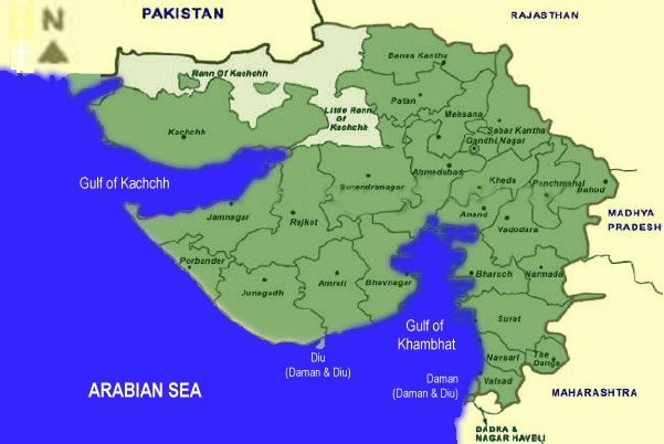 - The southeast situated along peninsular India's westcoast (north of Mumbai/Bombay), bordering to Maharashtra state in the south and west and Madhya Pradesh in northwest. it is here where the mountainous range of the Western Ghats start that then further stretches all along of India's western coast to the very southern tip. This area is developing very fast, as it is heavily industrialized. Surat, which is known for it's diamond polishing industry, is said to be the worlds fastest growing city. - The northeast with the political capital Ghandinagar and the commercial capital Ahmedabad, bordering to the states of Madhya Pradesh in southwest and Rajasthan in west and north. This is Gujarat's main region for textile production and dairy farming. - The northwestern region is called Kutch (or Kachchh) and is mostly a dry desert area. This area is a earthquake prone zone and has been devastated by a massive quake in 2000. It is embedded between the Rann of Kutch in the north, the little Rann of Kutch in the east, the gulf of Kutch in the south and the Arabian Sea in the west. In the very northwest it borders to Pakistan and in the very northeast to Rajasthan. - The southeastern region is the Kathiawar area (or province of Saurashtra). This is where we are located. This region is framed by the Gulf of Kutch in the northwest, the Arabian Sea in the west and south, the gulf of Khambhat (Cambay) in the east and the Little Rann of Kutch in the North. Its central city is Rajkot which lies in the main agricultural belt of the region and which is gaining importance as industrial hub, mainly for mechanical and elctric engineering and automobile. Jamnagar to its west is home to the large refineries due to its proximity to the gulf of kutch with its terminals for large tankers. History Signs of civilization in the region that is now Gujarat date back to the period from 3000 to 1500 BC. In 1818 the English East India Company took control of Gujarat. Before India became independent from the British in 1947, the Kathiawar area was consisting of several princely states, who acknowledged British sovereignty but retained some local autonomy. The British however ruled the eastern region of the peninsula directly and the entire peninsula was under British India's Bombay Presidency. After independence this princely states of Kathiawar were grouped into the Province of Saurashtra, which became a state in 1950. 1956 this state was merged into Bombay state and in 1960 Bombay state was split - considering linguistic lines - into the newly formed states of Gujarat and Maharashtra. Diu, a small island off the southcoast of pensinsular Gujarat was remaining a Portuguese colony until 1961, when it was occupied by India and one year later it was integrated into India as part of the union territory of Goa, Daman and Diu. Politics Gujarat has a single-chamber legislative assembly with 182 members. The state sends 37 members to the Indian national parliament: 11 to the Rajya Sabha (Upper House) and 26 to the Lok Sabha (Lower House). Local government is based on 19 administrative districts. Ruling party is BJP under CM Narendra Modi (reelected Dec. 2007) Economy Gujarat is one of India's most industrialized states with main industries in textiles, general and electrical engineering, watches, cars and components, vegetable oils, chemicals, cement, minerals, fertilizers, petroleum derivates, pharmaceuticals, salt and dairy. Power production: Nuclear, hydroelectric, wind, thermal (gas and coal) Kandla is a major international shipping terminal and India's largest free trade zone. Gujarat accounts for: · 20% of India's Industrial Output · 9% of India's Mineral Production · 22% of India's exports · 24% of India's textile production · 35% of India's pharmaceutical products · 51% of India's petrochemical production Gujaratis living abroad (mainly in US and UK) are probably indias major diaspora and their wealth is an important factor in the states economical development. Travel and Tourism Domestic airports: total 12 International airport: Ahmedabad (limited choice of destinations) note: Access to Gujart for tourism is usually via Mumbai (Bombay) Airport using a connecting domestic flight to one of Gujarats cities. Our projects site is accessible via Jamnagar, Porbandar or Rajkot. Railways: total length 5,268 kms Roads: total length 72,950 (road quality improving rapidly as all major roads are currently being rebuilt). Gujarat has a coastal line of 1,600 kms (the longest single state owned in India) with some nice stretches of beach. However, most of it is touristically undeveloped. climate: 27º C to 42º C in summer, 14º C to 29º C in winter, monsoon is from June to Sept., best time to visit is October to March. Some places of interest: Temples, religous and archeological sites: Dwarka (reffered to as Krishna's birthplace), Somnath, Verawal, Gir Hills and Palitana, Udwada, Lothal and Modhera. National parks and wildlife sanctuaries: Guajarat has 4 national parks and 11 sanctuaries. Interesting visits to Bird Sanctuary at Saroval, Maritime National Park at Jamnagar, Sasan Gir (the world's last habitat of the Asiatic lion). A scenic spot to visit is also the small Diu Island off the southern coast. It has retained some of it's portuguese flair and there are some nice sandy beaches. Diu is accessible via its own airport. Diu is also a popular destination amongst more localised tourism due to the availability of liquor, as opposed to Gujarat, which is a dry state (alcohol prohibition). Facts and Figures about Gujarat area: 196,024 sqkm Population: approx 42 Mio. Villages: 18,584 Ratio urban population: 34.5% Ratio population involved in agriculture: approx. 2/3 Gross area cropped: about 50% of total land area Staple crops: wheat and millets cash crops: cotton, peanuts and other oilseeds, tobacco, sugar cane Literacy: Ø approx. 61% Universities: 10 (amongst them the Indian Institute of Management in Ahmedabad and the University for ayurvedic science in Jamnagar) top
design, texts and pictures of this website are © 2007-2009 by invitra.org
site concept and design by creagenzia you may use this content with our permission, please contact us. |